Devil's Knuckles
The unique rock formations next to the road on the left-hand side, 21km
from Sabie, are named Devil's Knuckles. On the right-hand side of
the road there is a magnificent view of Sabie.
Long Tom Cannon Replica 
On the left-hand side of the road, 21.3km from Sabie, is a replica of a Creusot siege
cannon. The monument marks the spot where, from 8 to 11 September 1900, two of
these cannons were use for the last time by the Boer commandos against the British army.
These cannons - with their long barrels - were nicknamed the "Long
Toms" by the British forces. For more information and photo, see our
Picture Gallery page.
Blue Swallow Nesting Site 
The Misty Mountain Chalets is on the Misty Mountain Natural Heritage
Site, one of the few remaining sites where the endangered blue swallow
still breeds. There is no guarantee that you will see a blue
swallow, but the restaurant at Misty Mountain Chalets serve great
breakfasts. For more information on this heritage site, see our Natural
Heritage page.
Old Wagon Route
Beyond Misty Mountain, near The Staircase, is a signboard to the old
Wagon Route. This treacherous route was used by the Voortrekkers
and transport riders more than a 100 years ago.
Long Tom Pass
There are a number of view sites on the Long Tom Pass, one at 29.4km
and the other at 31.4km from Sabie. Both offer breathtaking views
of the Sabie valley, more than a 1,000m below. The highest point
of the tarred road (2,150m a.s.l.) is 34.9km from Sabie.
Gustav Klingbiel Nature Reserve & Museum 

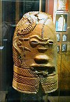 This
2,200 ha reserve is 51.7km from Sabie (2.9km from Lydenburg).
The reserve is a sanctuary for more than 100 bird species, a number of
smaller game and mammal species, as well as for a rich variety of flora.
This
2,200 ha reserve is 51.7km from Sabie (2.9km from Lydenburg).
The reserve is a sanctuary for more than 100 bird species, a number of
smaller game and mammal species, as well as for a rich variety of flora.
Archeological
ruins (dating back to the Later Iron Age) consisting of stone walled villages
and agricultural terraces, as well as the remains of Anglo-Boer War
forts are preserved on the reserve. Replicas of the well known 800
year old Lydenburg Heads, found in the area, are housed in
the museum.
Times: 08:00 - 16:00 (weekdays)
08:00 -
17:00 (weekends)
Fees: R10/person
Lydenburg Waterfocus Centre 
The Waterfocus Centre is at the entrance to Lydenburg town. The aim of the Waterfocus programme at
the Centre is to highlight man's dependency on the environment in
general and on water in particular. Casual day visitors tour the
Centre on their own and, by prior arrangement, guided tours are on offer
for larger groups. The fun-filled, hands-on activities include a
freshwater aquarium, a "feelie" pool and fish-feeding. This is an educational must-visit tourist attraction for kids as the
water awareness themes are based on the school curriculum. Indigenous plants are for sale at their nursery.
Times: 08:00 - 16:00 (daily)
Lydenburg Town 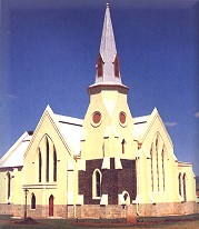
The
town of Lydenburg (55km from Sabie) have a rich history associated with
the Voortrekkers and the Anglo-Boer War. The name "Lydenburg"
means Place of Suffering and the town was so named after the many deaths
of Voortrekkers at Ohrighstad due to malaria. In 1856 De Republiek
Lijdenburg in Zuid Afrika was formed with Lydenburg as the
capital. A year later this independent republic merged with the
republic of Utrecht (in KwaZulu-Natal) and in 1860 became part of the
Zuid-Afrikaansche Republiek once again.
 The
first church in Lydenburg was completed in 1853. It is located in
Kerk Street, and is the oldest church outside of
the Cape Province that survived the wars of the country. Near the church is the original Voortrekker school. It
was built in 1851 and was also used as a church building before the
church was completed. The Dutch Reformed church was build in 1890
and features a superb pulpit (made from kiaat wood) which is an exact
replica of the Stellenbosch Church pulpit.
The
first church in Lydenburg was completed in 1853. It is located in
Kerk Street, and is the oldest church outside of
the Cape Province that survived the wars of the country. Near the church is the original Voortrekker school. It
was built in 1851 and was also used as a church building before the
church was completed. The Dutch Reformed church was build in 1890
and features a superb pulpit (made from kiaat wood) which is an exact
replica of the Stellenbosch Church pulpit.
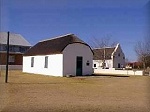
Gunpowder Magazine
 The
Gunpowder Magazine (located in Viljoen Street) was built in 1883. It was in constant use by the
various occupants of the town from the time of the Sekhukhune War of
1897 (when the British 94th Regiment was stationed in Lydenburg), through
to the first South African War of 1881. The building was completed in
1890, declared a national monument in 1962 and restored in 1982.
The
Gunpowder Magazine (located in Viljoen Street) was built in 1883. It was in constant use by the
various occupants of the town from the time of the Sekhukhune War of
1897 (when the British 94th Regiment was stationed in Lydenburg), through
to the first South African War of 1881. The building was completed in
1890, declared a national monument in 1962 and restored in 1982.
Lydenburg Waterfall & Hydro-Electric Plant 
This beautiful waterfall is seldom seen by the public due to poor
promotion and poor road sign directions. Travel on the R36 towards
Ohrigstad for 10km and be on the lookout for a small, inconspicuous signboard on the left
pointing to the waterfall which is a further 6km along the gravel
road. The falls are actually made up of three separate falls with a
combined height of 244m.
The old disused (but still maintained) hydro-electric plant is close by.
Times: 09:00 - 16:00
Fees: R20/vehicle
Ohrigstad Dam and Nature Reserve
From Lydenburg, travel towards Ohrigstad on the R36 for 27km before
turning off to the right on the R533 towards Pilgrim's Rest. The
turnoff to the Ohrigstad Dam and Nature Reserve is 9.6km further and
the dam another 4km along the gravel road. The reserve covers an
area of 2,564 ha of scenic mountain terrain surrounding the dam. Canoeing, rowing and angling from powerboats are permitted on the dam.
Times: 06:00 - 18:00
Fees: R25/adult, R15/child (under 12 years) + R5/vehicle
Robbers Pass
During the gold rush days the coach from Pilgrim's Rest to Machadodorp,
via Lydenburg, ran twice a week. On two occasions it was robbed on
the pass between Pilgrim's Rest and the junction between Ohrigstad and
Lydenburg. This pass (now the R533 road) was appropriately named
Robbers Pass. Today this road is a wide and very scenic tarred
road winding its way through the grass-covered hills down to the
historic town of Pilgrim's Rest. This is also the route followed
by Sir Percy Fitzpatrick and his legendary dog Jock. Two
Jock waymakers mark this route.
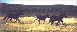
Wild Horses
As you descend Robbers Pass, keep an eye open for a herd of wild
horses on the left-hand side of the road near Morgenzon
plantation. If you do spot them consider yourself very fortunate,
as they are seldom seen.